Enabling access to local historical information for everywhere
Submitting Institution
University of PortsmouthUnit of Assessment
Geography, Environmental Studies and ArchaeologySummary Impact Type
CulturalResearch Subject Area(s)
Information and Computing Sciences: Artificial Intelligence and Image Processing, Data Format, Information Systems
Summary of the impact
The Great Britain Historical Geographical Information System (GBHGIS) has
computerised geographical surveys of Britain, including Ordnance Survey
mapping and all censuses 1801-1971, integrating them into a consistent,
innovative geo-spatial and geo-semantic information architecture, and
disseminated data via many channels including the UK Data Service, direct
work for government agencies (e.g. DEFRA, National Archives), and our own
very popular web sites that are used extensively by genealogists and the
general public with over 1.8 million unique users per annum. Impact of the
technical innovation is mainly on non-UK academics, but within the UK we
have made it vastly easier to place modern local issues in long-run
perspective — and lots of people and organisations have.
Underpinning research
The last twenty years have seen the emergence of historical GIS as a
significant sub-discipline, and as the technical underpinning of the
humanities' "spatial turn" (ie revisiting the importance of `place').
However, most research in the field relies on a routine application of
commercial GIS software. The original GBHGIS was already a partial
exception, innovating by incorporating a continuous time dimension within
commercial GIS software. That system's success led to wide contacts beyond
academic historical geography(6), including medical researchers(g),
official statisticians(f), environmental agencies(b), archivists and local
historians; through them to an awareness of the limitations of traditional
GIS data models; and to National Lottery funding(a) both enabling and
requiring us to address these wider needs.
Traditional GIS excels at organising information around a coordinate
framework, then visualising the big picture. However, in historical
sources locations are often the least certain part of our knowledge and
many users are seeking needles in haystacks, not big pictures. More
specifically, historical information is "geographical" through containing
place names, not coordinates, and "places" change names over time. In 2000
Dr. H Southall was appointed as Reader in Geography at Portsmouth and led
the development of a radically different information architecture
addressing these issues, geo-semantic as much as geo-spatial, underpinning
a quite new GBHGIS, which supported the web site, "A Vision of Britain
through Time", launched in 2004(3, 4, 5).
The resulting architecture systematically enumerates legally-defined
administrative units and, separately, less formally defined "places". The
system can hold point locations or boundary polygons for units, but the
only absolute requirement is for hierarchic relationships, enabling units
to be inserted from sources like taxation lists. The system is massively
poly-hierarchic, with approximately three times as many relationships as
entities. The published web site is very large, currently including 22,371
"place" pages, 79,265 administrative areas and 14.1 m. data value pages,
and has been both popular and influential. More technical publications
emerged from work funded by the European Union in 2006-8(c) to
internationalise the architecture and cover Estonia and Sweden(2).
Our work in 2001-4 developing the new architecture predates most
geo-semantic research by information scientists, and differs from it in
several other respects:
- Our geo-spatial ontology derives from existing scholarly works,
notably Youngs' Guide to the Local Administrative Units of England
and other authorities identified by the National Council on Archives,
who supported our lottery bid.
- Our ontology is far larger, linking over 100,000 entities by over
300,000 relationships and our architecture consequently addresses
scalability issues.
Our information about places and units is a systematic framework for a
much larger corpus of statistical data values. So that data could be
retrieved equally easily as cross-sections, for mapping, and as time
series, all statistics are held in one column of a single table, and this
required development of a second ontology of statistical concepts,
starting with high-level concepts like "land use" but extending down to,
for example, systematic capture of the crop classifications used by the
British Farm Census(e), or the numerous age classifications in different
Population Censuses(1, 3). The system's contents continue to be expanded
with JISC(d, h) and other funding(i).
References to the research
1. Southall, H (2008) Visualization, data sharing and metadata. In: Geographic
Visualization: Concepts, Tools and Applications. John Wiley,
Chichester, pp. 259-275. Available on request.
2. Southall, H, Von Luenen, A and Aucott, P (2009) On the organisation of
geographical knowledge: data models for gazetteers and historical GIS. In:
E-Science Workshops, 2009 5th IEEE International Conference on.
IEEE, Oxford, 162-166. Available on request.
3. Southall, Humphrey (2011) Rebuilding the Great Britain Historical GIS,
Part 1: building an indefinitely scalable statistical database. Historical
Methods: A Journal of Quantitative and Interdisciplinary History, 44
(3). pp. 149-159. DOI: 10.1080/01615440.2011.589774
4. Southall, Humphrey (2012) Rebuilding the Great Britain Historical GIS,
part 2: a geo-spatial ontology of administrative units. Historical
Methods: A Journal of Quantitative and Interdisciplinary History, 45
(3). pp. 119-134. Ref2 output: 17-HS-001
5. Southall, Humphrey (in press) Rebuilding the Great Britain Historical
GIS, part 3: Integrating qualitative content for a sense of place. Historical
Methods: A Journal of Quantitative and Interdisciplinary History.
(Preprint at
http://eprints.port.ac.uk/10059)
6. Southall, Humphrey (in press) Applying Historical GIS beyond the
Academy: Four Use Cases for the Great Britain HGIS. In: Towards
Spatial Humanities. Indiana University Press, Bloomington, pp.
92-117. (Preprint at http://eprints.port.ac.uk/10061)
Grants Awarded
A total of 43 awards have supported the development of the GB Historical
GIS; full details available on request. The following are referenced here:
a. New Opportunities Fund (a National Lottery distributor), `Great
Britain Historical GIS/Gazetteer/Atlas— A Vision of Britain through Time',
£706,271 (July 2001)
b. Environment Agency, `1930s Land Utilisation mapping: an improved
evidence-base for policy?' £9,078. (Dec. 2005)
c. European Union Framework Programme 6, `QVIZ: Query and context based
visualization of time-spatial cultural dynamics', £145,342 (Portsmouth's
share of a larger grant; May 2006)
d. Joint Information Systems Committee, `Historic Boundaries of Britain:
Constituencies and Elections 1832-1974', £398,700 (April 2007)
e. Dept. for the Environment, Farming & Rural Affairs, `Developing
June Agricultural Census Historical Data', £ 9,790 (May 2007)
f. Economic and Social Research Council 2011 Census Programme, `CAIRD:
Census Aggregate Information Resource Demonstrator', £4,856 (Portsmouth's
share of MIMAS-led project; May 2008)
g. Economic and Social Research Council, `HALCyon: Healthy Ageing across
the Life Course', £29,343 (Portsmouth's share of Medical Research
Council-led project; Sept. 2008)
h. Joint Information Systems Committee, `Embedding A Vision of Britain
through Time as a resource for academic research and learning', £35,048
(Sept 2010)
i. Frederick Soddy Trust, Sources & frameworks for long-run
geographical change in Britain, from the middle ages to 1831', £40,450
(March 2011)
Details of the impact
Our technology makes historical information about Britain's places widely
available and easily findable.
The National Archives create finding aids for archivists and the general
public. "The existence of the GBHGIS and its ready accessibility through
the Vision of Britain' website has obviated the need to develop a separate
GB place name authority file. ... [We] have been working with you [for
over 10 years] ... and I have been very impressed by the continual
development of the GBHGIS from its earliest beginnings to the rich
resource that exists today.... Successive revisions and upgrades have
refined and expanded your data to the point where archivists and their
customers can have great confidence in the accuracy and comprehensiveness
of the resource. [Your] approach, combining GIS technology with the
information science concepts of thesauri and ontologies, has created an
innovative product which meets [our] needs far more thoroughly than would
... off-the-shelf technology"(1, 10).
Our statistical metadata techniques have served the Office of National
Statistics in two ways: influencing their dissemination of 2011 census
data, via "a significant contribution"(4) to CAIRD: the ESRC-funded Census
Aggregate Information Resource Demonstrator, i.e. a prototype
dissemination system, and by ourselves directly disseminating earlier
data: "Whilst ONS publishes data from the more recent censuses (1971
onwards) on its websites it lacks resource to web publish data from
earlier Censuses ... Vision Of Britain has provided users with not only
[such] data but detailed supporting information and analysis ...
Comparison over time between Censuses is complicated firstly by changes in
administrative, enumeration, and statistical boundaries and secondly by
the changes in questions, definitions, and coding systems. The [GBHGIS]
team have developed a substantial understanding of techniques to manage
these changes"(4, 9) The same techniques "greatly assisted DEFRA both in
analysing long term trends in agriculture, and in providing public access.
In particular, the construction of a formal concordance relating the many
different classifications of crops and animals used by the annual Farm
Census since 1866 enabled new uses of the data as time series"(5).
A Vision of Britain through Time launched in October 2004. We have
maintained this open access web site for nine years, steadily enhancing
its content. Usage has grown steadily (NB most academic historical sites
rarely exceed 10,000 monthly unique users):
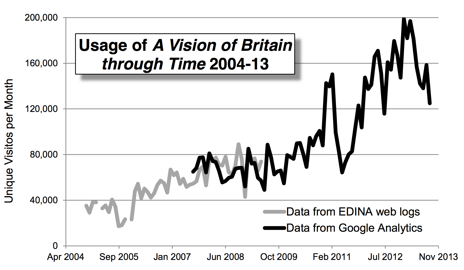
Over the year to 26/9/2013, the site was used by 1,812,462 different
people, 79% from the UK; a significant fraction of total population. Some
users leave clear tracks; for example, there are 7,342 hyperlinks from
Wikipedia into Vision of Britain. Mostly, however, we are
supporting purely personal research in local and family history; but this
has great significance for the participants: it reinforces their sense of
identity, place attachment and community bonding, so contributing
substantially to well-being and mental health.
The reasons why our site is so useful are summarised by Britain's leading
author on genealogical use of the internet, whose publications include The
Genealogist's Internet published by the National Archives: "What
distinguishes Vision of Britain for family historians is that its
material on the history of places is coherent, authoritative and national
in coverage, providing information essential for locating appropriate
genealogical records and contextualising, geographically, an individual
family's history. Genealogists need to build up complex pictures of
people's interaction with the landscape, and to understand the
geographical character of particular places: for example, reasons why
their ancestors moved in or out, such as industrial expansion or
unemployment rates. Because the site integrates a range of disparate
resources, it has the particular merit over more narrowly focused projects
of alerting users to sources of information that they may have been
unaware of"(2).
Recognition as a reliable source of local historical information has led
to wide use by local authorities: drawing a random sample of 50 from the
151 English county, borough and unitary authorities, at least eighteen
(36%) of their web sites reference us, as an authoritative source of
information for reports or a recommended resource for library users(8).
(7) exemplifies the former while(6), a retrospective looks at all
Britain's cities which received extensive press coverage, is the largest
scale use of our data by the sector.
Underpinning all this is our expertise in structuring information for
effective spatial discovery, taken further in our Old Maps Online site
launched in 2012, and listed by the British Library as among "100 Websites
which [curators] judge will be essential reading for future generations
researching our life and times in 2013", alongside Facebook and Twitter:
"this type of visual search is revolutionising the way in which we conduct
historical research and will be invaluable for future researchers wishing
to dive through layers of history geographically"(3).
Sources to corroborate the impact
- Supporting letter from the National Archives, as excerpted in section
4.
- Supporting letter from expert on genealogical use of internet, as
excerpted in section 4.
- British Library (2013) 100 websites: Capturing the digital
universe: The Curators' 100:
http://www.bl.uk/100websites/top100.html.
A list of culturally
"essential" web sites including our work.
- Supporting letter from Office of National Statistics, as excerpted in
section 4.
- Supporting letter from Department of the Environment, Farming and
Rural Affairs, as excerpted in section 4.
- Centre for Cities (2012) Cities Outlook 1901: http://www.centreforcities.org/assets/files/2012/12-07-10_Cities_Outlook_1901.pdf
A report by a local authority-funded think tank drawing heavily on our
work.
- Hampshire County Council (no date) A demographic profile of Hampshire
County's past 1801-2001: http://www3.hants.gov.uk/hampshire_county_historical_profile-3.pdf
A typical example of a local authority report using our data.
- Surveying local authority use of A Vision of Britain through Time.
A short note documenting this survey and listing the online resources we
found.
- Southall, H (2007) A vision of Britain through time: online access to
"statistical heritage". Significance, 4 (2). 67-70. An account
of how we make historical statistics for particular localities
accessible to a general audience, itself appearing in the general
interest magazine of Royal Statistical Society.
- Southall, H (2010) Alternative ways of indexing by geography. ARC
(magazine of the Archives and Records Association) (254) 17-19. http://eprints.port.ac.uk/5095/1/2010_Arc_Magazine.pdf
Presenting
our approach to organising geographical information to archivists.