Monitoring and management of German forest
Submitting Institution
University of BathUnit of Assessment
Mathematical SciencesSummary Impact Type
EnvironmentalResearch Subject Area(s)
Mathematical Sciences: Statistics
Economics: Applied Economics
Summary of the impact
Forests are economically, recreationally and ecologically important,
providing timber and wildlife
habitat and acting as a carbon sink, among many ecosystem services. They
are therefore
extremely valuable to society, and it is crucial to ensure that they
remain healthy. A statistical
model has been developed in Bath to estimate spatio-temporal trends of
forest health from
monitoring data. This work has led directly to more efficient data
collection, and to new and
improved interventions to mitigate the impact of pollution and climate
change (such as soil liming to
control acidity and reforestation regimes). The methodology has been
adopted for official reporting
in the yearly 'Waldzustandsbericht (Report on Forest Condition)'
[A-E] of the German state
Baden-Wuerttemberg (BW), which is 39% forested, an area of 14,000km2
with an estimated stock
value of 17 billion US$.
Underpinning research
The statistical model [1] is a result of an on-going collaboration
between Augustin (Senior Lecturer
at Bath, appointed as a Lecturer in 2005) and the Forest Research
Institute (FRI), BW, Germany,
part of the Ministry of Rural Affairs and Consumer Protection of BW,
together with Wood (Professor at
Bath since 2006). Augustin had previously collaborated on research with
the FRI while working in
Germany, but the Bath grants and consultancy agreements from the FRI [2]
and the Royal Society
[3] led directly to her new method for the spatio-temporal estimation of
tree health [1]. Data on
forest health from other German states are collected differently; the BW
data are the most dense in
terms of spatio-temporal resolution, and are therefore the most suitable
for method development.


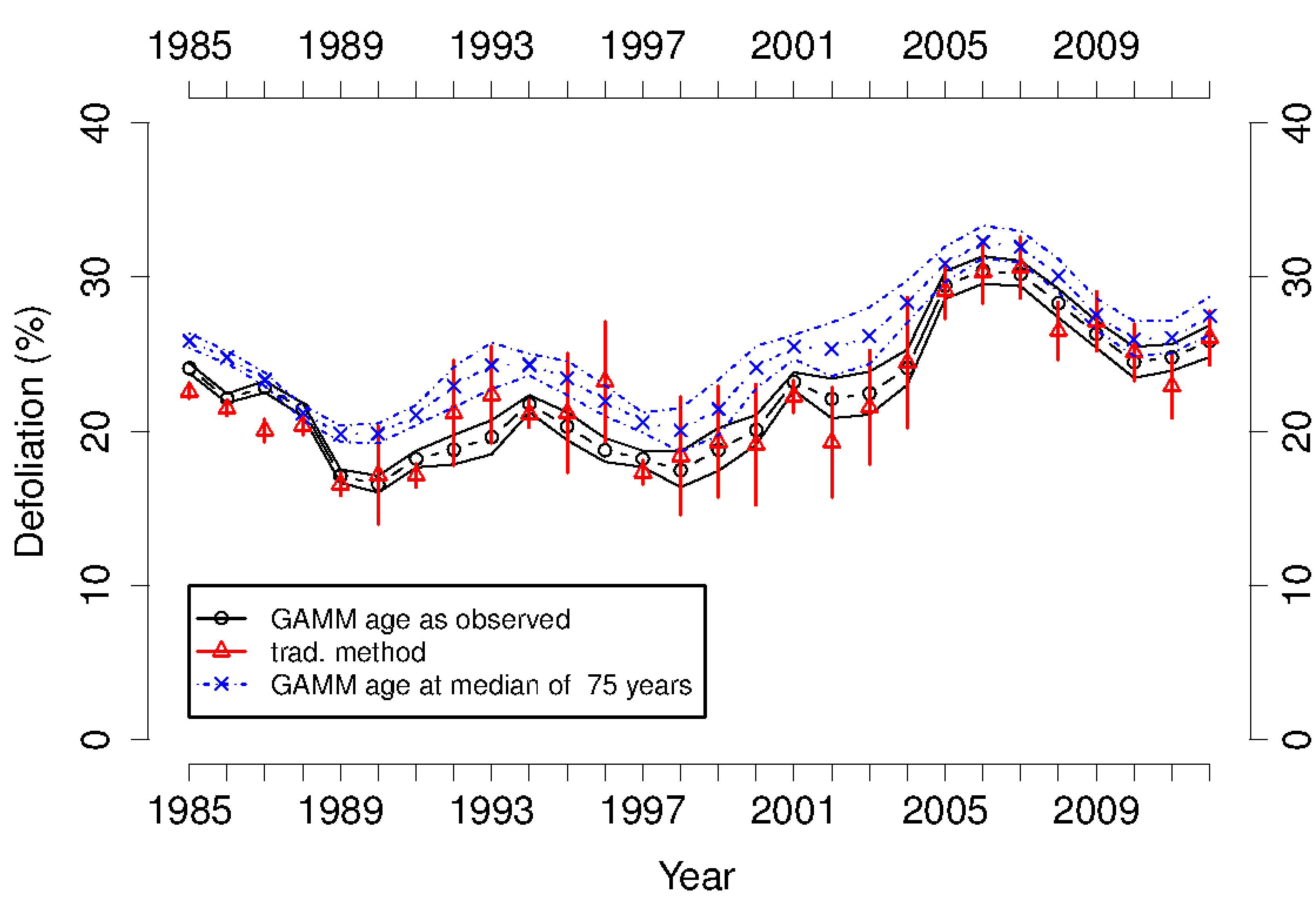
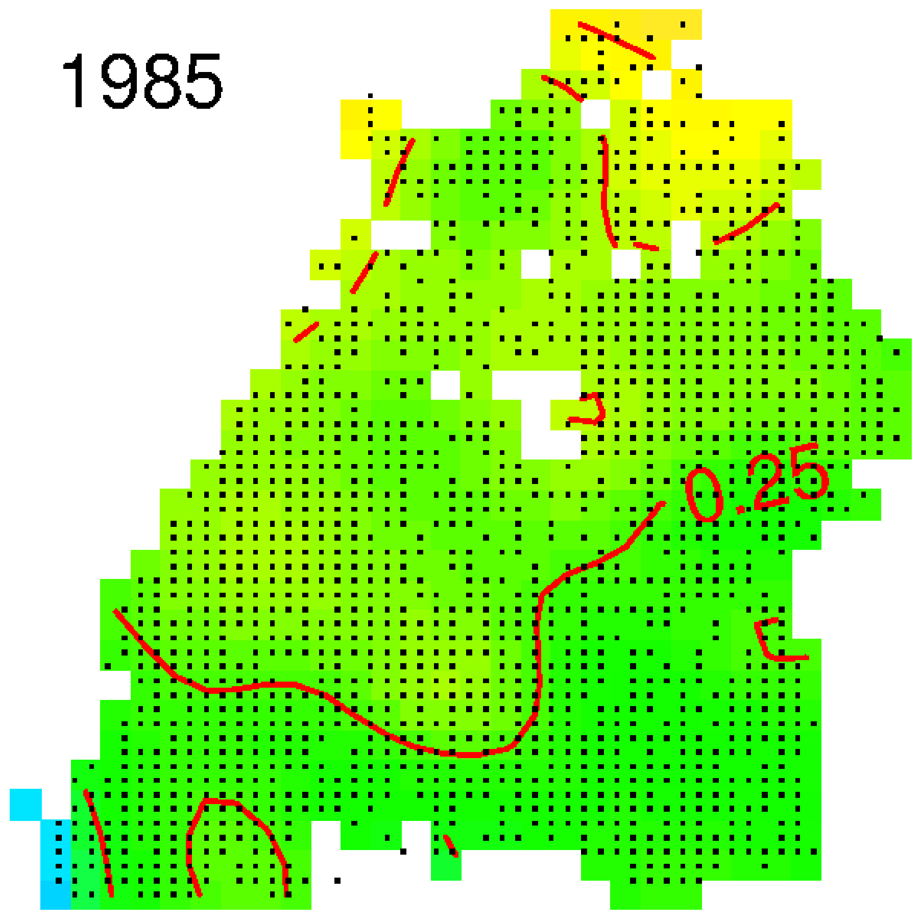
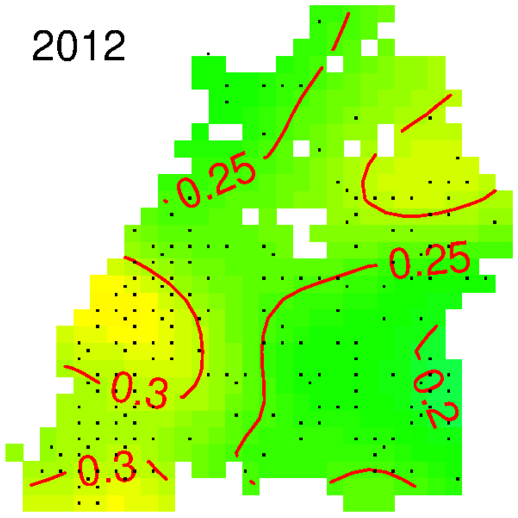
 Figure Temporal (left) and spatial (right) estimates of
spruce tree health, indicated by defoliation in
the crown. Left: temporal trend estimates from the traditional
method are the red triangles with
95% confidence intervals; temporal trend estimates from the new method
with age as observed and
standardised for age are the black circles and the blue crosses
respectively, both with Bayesian
95% confidence bands. Right: spatial maps for spruce of median
age, unobtainable with the
traditional method. The black dots indicate the sampling locations, the
red isolines indicate the level
of defoliation in the crown (yellow is high defoliation of at least 30%,
green is medium defoliation at
25%).
The traditional method (Fig. left, red triangles) estimates mean
defoliation separately for each
year using summary statistics from the monitoring surveys. The method
delivers temporal but not
spatial trend estimates, and the attached confidence intervals do not take
the spatio-temporal
correlation and age structure of the data into account. It cannot be used
for inference, since
ignoring correlation in the data may result in biased trend and variance
estimates.
The new method uses the framework of generalized additive mixed
models (GAMMs). Augustin,
Wood and collaborators developed a new modelling approach that accounts
for possible spatial
and temporal correlation and incorporates important predictors [1] while
being computationally
efficient in parameter estimation. The model for the response mean tree
defoliation was developed
using the moderately large annual BW monitoring data, which were sampled
on a grid with yearly
varying resolutions of 4X4 km, 8X8 km and 16X16 km. Hence each year from
1983 to 2012, a
subset of the 1910 unique grid locations were chosen, and 24 trees were
sampled at each, giving in
all 180,000 observations of individual tree crown defoliation. The model
included space-time
interactions, as the temporal trend of defoliation differs between areas
with different characteristics
and pollution levels. It also included a non-linear effect of mean tree
age, the most important
predictor variable, allowing the separation of trends in time, which may
be pollution-related, from
trends that relate purely to the ageing of the survey population, as shown
in the left panel of the
Figure.
GAMMs allow for non-linear effects of explanatory variables, random
effects, general correlation
structures for cases where the data are not independent and any response
with a distribution from
the exponential family. The novel aspect of [1] is a scale-invariant
tensor-product smooth of the
space-time dimension, which improves on existing methodology for
estimating spatio-temporal
trends. These tensor-product smooths allow combinations of different basis
functions most suitable
for the dimensions of space and time as well as time-varying spatial
estimates. Hence the
smoothness parameters and penalties can be separate for time and space,
avoiding the need to
make arbitrary choices about the relative scaling of space and time. In
addition to a temporal trend
due to site characteristics and other conditions modelled with the
space-time smooth, random
temporal correlation at site level is accounted for by an auto-regressive
moving average (ARMA)
process. The method does not rely on a regular grid and allows
incorporation of a wide range of
correlation structures. The model can incorporate non-linear effects, e.g.
for mean tree age, the
most important predictor. It provides predicted spatial maps of
defoliation and marginal estimates of
average defoliation over time with Bayesian confidence bands (Fig.), hence
allowing estimation of
trends in forest health and identifying possible causes of health
deterioration, so that rapid or
unusual change, in particular, can be detected as early as possible.
Communication of results and future development.
Spatio-temporal trends based on [1] are
communicated to policy makers and forest managers via the
Waldzustandsbericht BW. Since 2011
Augustin has been named as a coauthor of these yearly reports [A-E], but
she has made
substantial contributions since 2006. She has also co-authored an article
in a forest trade journal
(AFZ — Der Wald) on the impact of forest ecosystem monitoring,
recommending the introduction of a
permanent liming campaign as a tool to mitigate effects of pollution [F].
The main output [1] has
been cited in several articles of AFZ-Der Wald. The citations of [1] show
that the methods are
widely used, with applications in fisheries, epidemiology and ecosystem
monitoring through satellite
images. Software implementing the methods of [1] has been made available
to scientists at other
forestry institutes in Germany on request. Augustin has a PhD student
working on spatio-temporal
modelling of the entire European forest health monitoring data from the
UNECE International
Cooperative Programme on Assessment and Monitoring of Air Pollution
Effects on Forests
(http://icp-forests.net).
References to the research
References that best indicate the quality of the underpinning research
are starred.
[1]* Augustin, N.H., Musio, M., von Wilpert, K., Kublin, E., Wood,
S. and Schumacher, M. 2009.
Modelling spatio-temporal trends of forest health monitoring data. The
Journal of the American
Statistical Association. 104(487): 899-911. DOI:
10.1198/jasa.2009.ap07058.
[2] Augustin (PI). 'Modelling Forest Inventory Data' , Forestry
Research Institute Baden-
Wuerttemberg. 01/09/05 - 31/07/08 £52 754. Grant.
[3] Augustin (PI). 'Spatio-temporal modelling of tree defoliation
monitoring data', The Royal
Society. 01/04/06 - 31/05/09. £61 237. Grant.
Details of the impact
The main impact-related insights from the research are as
follows.
- The estimated trends provide evidence for increased defoliation of the
main species, spruce,
between 2004 and 2009, compared to previous years since 1985 (Fig.),
with a similar trend for
beech, the second most common species [E].
- Results also suggest that there has been a switch in the primary
drivers of damage: initial
damage can be associated solely with pollution, while more recent damage
is also associated with
drought years due to climate change. In addition to pollution, climate
change has become the most
severe threat to forest health in Europe, as some of the main species no
longer thrive in the
changed climatic conditions.
- The spatial trends highlight areas where intervention to improve
forest health is required, such as
liming to control acidity or planting species which are better suited to
the new climate conditions.
The research has led to improved forest health monitoring and
management, and we give four
examples below.
(a) Spatio-temporal models developed in Bath are used for
monitoring and management. The
methodology has been adopted for the yearly official report on forest
health of the federal state BW,
the 'Waldzustandsbericht/Report on Forest condition in BW' [A-E], which
drives the policy of the
Ministry of Rural Affairs and Consumer Protection, BW, Germany. In the
foreword of the 2012
report, the BW Minister for Rural Affairs and Consumer Protection,
Alexander Bonde, refers to the
Bath-developed methodology and results [E, pp 3-4].
"The Waldzustandsbericht makes it possible ... [for us] to make
management recommendations. ...
This is how trends can be recognised and strategies for sustainability
of our multi-functional forests
can be developed. ... [It] is the basis for counteractive measures
including policy on air pollution
control, ground liming and the creation of robust mixed forest stands.
... We use modern and
scientifically backed methods and instruments of forest ecosystem
monitoring to secure
sustainability of species diversity [and] wood production as well as the
protective and recreational
function of our forests, so that we can benefit from it in future."
(translation by Augustin)
(b) Improved sampling scheme in terms of cost-efficiency and
precision. Funded by [2, 3],
Augustin carried out a simulation study to optimise the sampling scheme
based on the spatio-
temporal model developed in Bath [1, A, B]. In particular, this work
results in a substantial cost
saving.
"The spatio-temporal model developed by Dr Augustin in collaboration
with the FRI BW and others
(see [1]) was crucial in assessing the cost-efficiency of the sampling
scheme for monitoring tree
health in BW. After about 20 years of changing sampling grids between
resolutions 4x4km, 8x8km
and 16x16km depending on available survey funds, a sampling grid of
8x8km is now used in BW.
This change in policy was a direct consequence of a simulation study
carried out by Dr Augustin
which in turn was based on [1]. This study showed that the much cheaper
and EU-wide used
16x16km grid resolution was not adequate in terms of detecting changes
in defoliation at a relevant
magnitude. The results also showed that the 4x4km grid resolution was
unnecessarily low for
achieving the required precision, and hence wasteful in terms of
resources. This resulted in a
yearly cost-saving of 100,000 Euros. [Our emphasis.] The
simulation study also showed up
problem areas with very high prediction errors which could then be dealt
with by inserting additional
sampling locations." [G]
(c) Improvement of forest growth conditions by reversion and
mitigation of pollution effects
on the soil through a forest liming programme. Spatial trend
estimates of defoliation produced
in Bath [A, B] were used by forest health managers to establish the need
and planning of a forest
liming programme in BW [C, F p.23].
"Moreover the reduction of sampling density in the crown condition
survey enabled direct linking of
the survey schemes on crown condition, forest nutrition and soil
condition. Thus synoptic
evaluation of data from these diverse monitoring schemes have been
enabled [H] which are a
sound basis for practical countermeasures of harmful effects of
environmental change, like e.g.
increasing deficiency in forest nutrition caused by acid rain and
subsequent soil acidification. A
central strategy for mitigating the effects of acidification is soil
protective liming.
Since 2006 Dr Augustin has produced spatio-temporal trend estimates of
defoliation based
on [1] for the yearly Report on Forest Condition / Waldzustandsbericht
published by the Forstliche
Versuchs- und Forschungsanstalt BW (FVA), Freiburg available at
http://www.fva-bw.de/ ). The
spatial trends she produced in 2008 and 2009 [A, B] established the need
for a forest liming
programme, and were used by the FVA in its plans for such a programme in
Baden-Württemberg
[C, F].
The aim of the forest liming programme is in the long term not only to
reverse the acidification
of the soil, but also to reduce the acid stored in the soil. The liming
programme entails on average
a yearly liming of 15,000 ha with a dosage of 3t/ha. This is altogether
45,000 t of lime which is
applied by turbine blowers from tractors or helicopters. In order to
reverse the effects of
acidification in the soil caused by pollution and improve growth
condition a long-term yearly liming
programme over the next 30 years is envisaged. Without
Augustin's work [1] it would have
been more difficult to convince the state government to fund the
programme, and we would
have much less confidence in a positive outcome." [G]. [Our
emphasis.]
(d) Adaptation to climate change. "The spatio-temporal
trends of tree health produced in Bath
highlighted particular areas where tree health is deteriorating due to a
combination of climate
change and soil condition. This contributed to a change in forest
management to plant better suited
trees and robust mixed stands. The spatio-temporal model of Augustin et
al. [1] on crown condition
allowed for proper identification of the spatial "hotspots" of crown
damages and revealed that they
changed from areas with soils, most susceptible to acidification (e.g.
Black Forest) to lowland areas
which are most susceptible for drought. This new spatial pattern of
severe crown damages is
observed since the year 2000 and is a strong indication for new, climate
change-related drought
stress." [G]
The research contributes to the conservation of the natural forest
environment in BW. Forest
managers, policy makers and members of the public will therefore benefit
from securing the
economic production, recreational opportunities, ecological features and
ecosystem services of the
forest, including its biodiversity and its role as a sink for atmospheric
carbon dioxide.
Sources to corroborate the impact
[A-E] Report on Forest Condition / Waldzustandsbericht, Forstliche
Versuchs- und
Forschungsanstalt Baden-Wuerttemberg, Freiburg. 2008-2012.
http://www.fva-bw.de/publikationen/index3.html
.
[F] von Wilpert, K. Schaeffer, J. Holzmann, S., Hug, R. Meining,
S, Zirlewagen, D. and Augustin,
N. 2010. Ableitung eines langfristigen Kalkungsprogramms. Was
Waldzustandserfassung und
Forstliche Umweltueberwachung bewirkt haben. AFZ- Der Wald. pp. 20-25.
Heft 3/2010.
http://ww.afz-derwald.de.
[G] Head of Department for Soil and Environment. FRI, BW.
Supporting Letter.
[H] Musio, M., v. Wilpert, K., Augustin, N. (2007): Crown
condition as a function of soil, site and tree
characteristics. European Journal of Forest Research. 126/1, 91-100,
doi:10.1007/s10342-006-
0132-8.