Animal-borne telemetry tags for conservation and weather forecasting
Submitting Institution
University of St AndrewsUnit of Assessment
Biological SciencesSummary Impact Type
EnvironmentalResearch Subject Area(s)
Earth Sciences: Oceanography
Environmental Sciences: Environmental Science and Management
Biological Sciences: Ecology
Summary of the impact
The Sea Mammal Research Unit (SMRU) in St Andrews designs, builds and
supplies
instrumentation and software essential for marine mammal tracking.
Specific impacts are:
- Direct economic benefit arising from the production of around 400
telemetry tags per
annum, employing 8 highly skilled staff with turnover of £5.6M since
2008.
- Companies in UK and USA supplying tag components have received over
£2M since 2008.
- Tags on Monk seals and Steller Sea Lions have enabled conservation of
these endangered
species whilst minimising economic hardship to fishermen.
- Tags on elephant seals in the southern oceans have improved Global
Ocean circulation
models significantly, leading to better weather forecasting and
consequent economic
benefits to shipping, oil and gas companies.
Underpinning research
The impact has been derived from fundamental research by Lovell
(in post since 1997),
McConnell (in post since 1996), Fedak (in post since 1996),
Boehme (lecturer since 2012) and
co-workers at the Sea Mammal Research Unit (SMRU) at the University of St
Andrews in the use
of space by marine mammals, especially seals. The at-sea behaviour of
seals is challenging to
study. Many species spend up to 90% of their lives underwater, often at
great distances from land.
Thus there is a need to develop technology and software to provide data
that resolves the
movement of animals in three dimensions from any location on the planet.
This required sufficient
accuracy of location and a capacity to transmit the data from the animal
itself because in most
cases there is no possibility of recovering information from an archive
tag by re-capturing the
animals. Consequently the Sea Mammal Research Unit at St Andrews has been
developing
instruments with this capability and these began to produce research
results in the late 1990s [1].
The technical challenges of building an instrument that would perform
appropriately were
substantial. These can be summarised as follows: instruments had to (a) be
robust enough to
survive the physical abuse from being attached to large marine mammals for
periods of months to
years; (b) withstand near-constant immersion in seawater; (c) be resistant
to hydrostatic pressures
down to that found at 2000 metres depth and to cope with pressure changes
from 1-200
atmospheres 10-20 times per day; (d) carry a
power supply (and power management system)
sufficient to collect data and then transmit the
data to an orbiting satellite over periods of
months to years; (e) carry and power enough
environmental and movement sensors to
sufficiently characterise the behaviour of the
animal, its location and its environment; (f) be
sufficiently small to not be a significant burden to
the study animal.
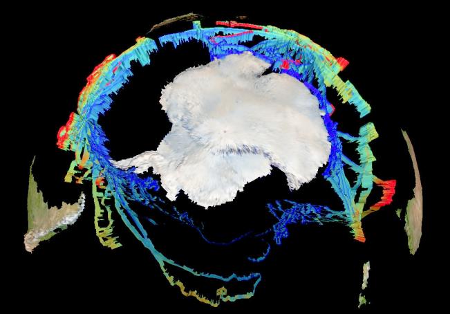
 Figure 1. Elephant Seals have provided
temperature profiles from the southern
ocean (image generated using MAMVIS)
The innovations within the instruments developed
to support SMRU's research represent some of
the key underpinning research of this project.
This included the need to develop dedicated
software to allow visualisation of data, addressed
by the MAMVIS software in 1996, which is freely
available for researchers (http://www.smru.st-andrews.ac.uk/
Instrumentation/DataProcessing/#
mamvis).
In 2001-02, novel algorithms to
compress data were developed, reducing power drain on batteries, which
allowed smaller or
longer-lived tags to be deployed [2]. This research activity also
allowed the locational errors
inherent in the ARGOS satellite system to be measured, to the benefit of
many other research
groups around the world [3]. The instruments have also been used
imaginatively to develop a
proxy measurement of deep ocean productivity by measuring relative changes
in the feeding
success of deep-diving seals using buoyancy changes resolved from the
vectors of force in the
vertical movement of seals in the water column. In work published in 2003
the detection of `drift
dives' and thus changes in buoyancy (=blubber stores) in southern elephant
seals permitted the
identification of their Antarctic foraging grounds with clear implications
for conservation [4]. The
development of novel sensors within the tags, especially to allow the
long-term measurement of
conductivity, allowed the deployment of animal-borne oceanographic sensors
that provide real-time
environmental data from some of the most inaccessible parts of the globe
such as the Southern
Ocean [5] (Figure 1). In parallel with the technical advances,
SMRU has developed new statistical
analysis tools and methods that maximise the derived information content
of the telemetry data [6].
References to the research
St Andrews contributors in BOLD. Employment dates in St Andrews:
Biuw 2000-2007; Boehme
2007-present; Fedak 1996-present; Hammond 1996-present; Hunter 1992-2003;
Lovell 1997-present;
Matthioupoulos 1997-2012; McConnell 1996-present
SMRU in St Andrews has published 546 papers in this area in the period
1996-2013, with over
10,000 citations, of which the following are a representative
cross-section with application to this
case study. These are all published in international, peer reviewed
journals.
[1] McConnell, BJ, Fedak, MA, Lovell, P, Hammond, PS (1999)
Movements and foraging areas
of grey seals in the North Sea. J. Appl. Ecol. 36: 573-590 DOI: 10.1046/j.1365-2664.1999.00429.x.
(88 citations).
[2] Fedak, MA, Lovell, P, McConnell, B, Hunter, C (2002)
Overcoming the constraints of long
range radio telemetry from animals: Getting more useful data from smaller
packages. Int. Comp.
Biol. 42: 3-10 DOI: 10.1093/icb/42.1.3.
(61 citations).
[3] Vincent C, McConnell BJ, Ridoux V, Fedak MA
(2002) Assessment of Argos location accuracy
from satellite tags deployed on captive gray seals Marine Mammal Science
18, 156-166.
DOI: 10.1111/j.1748-7692.2002.tb01025.x
(119 citations).
[4] Biuw, M, McConnell, B, Bradshaw, CJA., Burton,
H & Fedak, MA Blubber and buoyancy:
monitoring the body condition of free-ranging seals using simple dive
characteristics. J. Exp. Biol.
206, 3405-3423 (2003). DOI: 10.1242/jeb.00583
(58 citations).
[5] Biuw, M., Boehme, L., Guinet, C., Hindell, M., Costa, D.;
Charrasin, J.-B., Roquet, F., Bailleul,
F., Meredith, M., Thorpe, S., Tremblay, Y., McDonald, B., Park, Y.-H.,
Rintoul, S.R., Bindoff, N.,
Goebel, M., Crocker, D., Lovell, P., Nicholson, J., Monks, F.,
Fedak, M.A. (2007) Variations in
behaviour and condition of a Southern Ocean top predator in relation to in
situ oceanographic
conditions. Proc Natl Acad Sci USA, 104 (34). 13705-13710. DOI: 10.1073/pnas.0701121104
(112
citations).
[6] Aarts, G, MacKenzie, M, McConnell, B, Fedak, MA,
Matthioupoulos, J (2008). Estimating
space-use and habitat preference from wildlife telemetry data. Ecography
31: 140-160 DOI:
10.1111/j.2007.0906-7590.05236.x
(64 citations).
Details of the impact
The development of marine telemetry technology and associated
underpinning research by the
SMRU in St Andrews has resulted in 3 main areas of impact in the REF
period:
a) Direct economic impact from turnover totalling £5.6 million.
b) Conservation of endangered species such as the Monk Seal and Steller
Sea Lion.
c) Improvements in operational oceanography contributing to weather
forecasting and ocean
prediction with consequent economic benefits.
a) Direct economic impact from tag production
SMRU builds 300-400 telemetry tags per year and has generated a financial
turnover of £5.6M in
the REF period. This sustains 8 technical staff and engineers and funds
new development work to
maintain the instruments at the leading edge of the fast-moving field of
technology [S2].
Companies in the UK and USA have benefited by developing and supplying
specialised
components for the tags made in St Andrews, with sales totalling £2.03M in
the period 2008-13
[S3].
b) Conservation of species, marine spatial planning and species
management
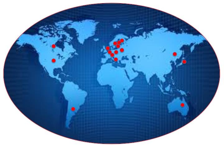
The instruments have been used by a
total of 44 institutions from 15 countries
world-wide (Fig 2) [S4]. The instruments
are used by national agencies to build
their knowledge of endangered or
threatened species, especially the habitat
they need to sustain themselves. This
allows judgements to be made about the
regulation of offshore industrial
developments, including fisheries. Specific
examples include:
 Figure 2. Global distribution of SMRU CTD tag
customers.
Hawaiian monk seal: In 2010-11, the
instruments enabled the compliance
monitoring for the US Navy in its offshore
ranges in the Hawaiian Islands [S5]. It is a
legal requirement that the US Navy shows
that it is not disturbing the highly
endangered Hawaiian monk seal and the instruments have been used to track
monk seals to
determine the extent to which there is overlap between the range over
which seals forage and the
regions in which US Naval exercises take place. By avoiding areas
frequented by monk seals, the
Navy was able to pursue offshore exercises without harming the species.
Steller Sea Lion: The instruments have been used to
determine the "critical habitat" for Steller sea
lions in the Aleutian Islands to provide the information necessary to
reduce the probability of
negative effects of fishing on the food supply for this endangered
species. It is a legal requirement
under the US Endangered Species Act to define critical habitat for species
classified as
endangered. This work was carried out by the US National Marine Fisheries
Service (NMFS) using
SMRU tags. The resulting Steller sea lion protection measures were set out
in a draft environmental
impact statement by the NMFS in 2013 [S6].
Columbia River Inter Tribal Commission: SMRU tags were used to
track California sea lion
movements to prevent damage to tribal fishing gear and stealing fish from
tribal nets (2013)
(
www.critfc.org)
Oregon Dept of Fish and Wildlife: SMRU tags were used to
track movements of Steller sea lions
to assess impact on fishery stocks in multiple states along the Columbia
River (2010)
(www.dfw.state.or.us)
Pacific States Marine Fisheries Commission: SMRU tags were
used to assess the impact of
seal populations on the fisheries industry (2010) (www.psmfc.org)
Pendoley Environmental Marine Conservation Environmental Services:
SMRU tags were
used to track offshore turtles to aid conservation efforts (2011) (www.penv.com.au)
Zoological Society London: SMRU tags were used to monitor
the health of Thames Harbour
seals to gain insight into their diet (2012) (www.zsl.org)
c) Operational oceanography contributing to weather forecasting and
ocean prediction:
Seal-borne instruments that measure conductivity and temperature during
the ascent and descent
portions of an animal's dive can provide information equivalent to that of
ARGO floats or ships. In
some circumstances — especially in polar regions where ice cover often
precludes measurement of
oceanographic profiles using conventional methods, seal-borne data are
input to the Global Ocean
Observing System (GOOS). GOOS is an international backbone for
oceanographic products and
services and is the principle focus for international cooperation in
operational oceanography.
Data from seal-borne instruments are automatically relayed to the World
Meteorological
Organization's Global Telecommunication System
(GTS). Since 2008, over 300,000 CTD profiles from
seals tagged with SMRU instruments have been
incorporated into the World Ocean Database
providing 56% of all oceanographic CTD profb01les
available for the Southern Ocean south of 60 °S [S7].
According to an independent oceanographic expert in
this area, quantification of the impact of SMRU CTD
tag data on the ECCO ocean model (one of the main
global ocean circulation models) was significant:
"
the use of seal data improved significantly (by
up to 30%) the representation of ocean
circulation south of the Antarctic Circumpolar
Current in the seasonally ice covered subpolar
zone, increasing the consistency of the
modelled sea-ice distribution"
[S1].
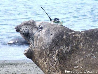
 Figure 3. CTD tag on Southern elephant
seal.
These models are utilised by a variety of marine industries and services,
including shipping (fuel
savings through optimal routing), oil and gas industries- in addition to
meteorological forecasting.
The combined impact of improved weather forecasting on these activities is
naturally very difficult
to quantify. However, in Australia alone, the commercial value of Global
Ocean Observing Systems
to such industries and services was estimated in 2006 as over A$ 600
million annually [S8].
Sources to corroborate the impact
[S1] Letter from an independent oceanographic expert at the
Department of Meteorology,
Stockholm University. Corroborates improvement in weather forecasting due
to SMRU-designed
animal-borne tags.
[S2] Audited statement of SMRU instrumentation group turnover and
production in the REF period
2008-13.
[S3] Audited list of invoices for SMRU instrumentation group.
[S4] List of institutions supplied with tags by SMRU
instrumentation group 2008-13.
[S5] Habitat Use and Behavioral Monitoring of Hawaiian Monk Seals
in Proximity to the Navy
Hawaii Range Complex. Report Period: August 2010 — July 2011. Department
of the Navy, 2011
Annual Range Complex Monitoring Report for Hawaii and Southern California,
Appendix M. See P
284. Corroborates Navy compliance policy.
http://www.navymarinespeciesmonitoring.us/files/2413/4749/5443/2011-HRC-SOCAL-annual-
monitoring-report_HRC_appendix-m.pdf
[S6] Steller Sea Lion Protection Measures Environmental Impact
Statement (EIS). Corroborates
proposed protection measures for Steller sea lions in fisheries off
Alaska.
http://alaskafisheries.noaa.gov/sustainablefisheries/sslpm/eis/
[S7] Corroborates number of animal-borne CTD profiles in Southern
Ocean. extract APB profiles at
http://www.nodc.noaa.gov/OC5/SELECT/dbsearch/dbsearch.html
[S8] Economics of Australia's sustained ocean observation system,
benefits and rationale for
public funding. Report by the Australian Academy of Technological Sciences
and Engineering,
(page 40). Corroborates financial value of the GOOS to the Austrailian
economy.
http://imos.org.au/fileadmin/user_upload/shared/IMOS
General/documents/external_reports/Economics_of_Australia_a_Sustained_Ocean_Observation_System_1_.pdf